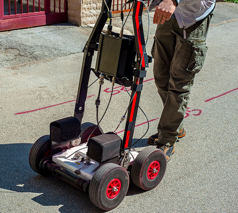
Subsurface Utility Locating with Ground Penetrating Radar Systems (GPRS)
Crigger Power uses advanced ground-penetrating radar systems (GPRS) to scan, map, and verify subsurface utilities before drilling or excavation begins. Our GPR services identify buried conduit, utilities, tanks, and concrete structures, reducing strike risks and keeping trenchless construction safe and compliant.
Trained technicians complete every scan in-house using high-frequency radar and real-time data collection. Whether we’re locating for a bore path, scanning slabs for structural integrity, or verifying as-builts, we deliver fast, accurate results without delays or third-party involvement.
Crigger Power scans it right for subsurface utility locating that protects the surface and the schedule.
Using GPRS for 811 Requests
Calling 811 is required before breaking ground, but the public utility locate system only covers registered assets. For everything it misses, Crigger Power uses GPRS to find private lines, unmarked conduit, and forgotten infrastructure that the dig ticket won’t catch.
Our crews scan the site before boring begins to identify potential conflicts, validate 811 locates, and reduce the risk of strikes or costly delays. GPRS is especially valuable on commercial, industrial, and private property sites where telecom, power, and water lines may not be documented.
Our techs map what’s below the surface in real time, giving you a complete picture of existing utilities before trenchless construction starts. It’s how we protect your jobsite—and how we drill with confidence.

Other Subsurface Services That Pair with GPRS Scanning
Ground Penetrating Radar Systems (GPRS) are a critical first step in trenchless planning—but they’re only part of the full picture. Crigger Power combines GPRS with our in-house boring and utility construction capabilities to eliminate guesswork, avoid conflicts, and accelerate underground builds.
Every service listed benefits directly from accurate subsurface data, whether it’s a roadway crossing, joint trench system, or deep conduit run.
Ground Penetrating Radar Systems (GPRS) FAQs
Before any trenchless boring or underground utility work begins, Crigger Power uses GPRS to scan and map what’s below the surface. These scans reduce risk, prevent utility strikes, and keep jobs on spec and on time.
Here are answers to the most common questions about GPRS and how it fits into our work across commercial, utility, and infrastructure sites. For deeper insights, visit our full Blog and FAQs library.
GPRS—short for Ground Penetrating Radar Systems—works by sending high-frequency radar pulses into the ground. When those signals hit different materials (like metal, plastic, concrete, or soil voids), they bounce back to the receiver, creating a visual scan of the subsurface. These scans are then interpreted in real-time to identify potential conflicts or utility lines.
This non-invasive method works through asphalt, concrete, and bare earth. It’s far more accurate than relying on outdated maps or painted locates alone, especially in areas with dense or undocumented utility layers.
Crigger Power uses GPRS to locate buried utilities, voids, and subsurface structures before we bore or trench. It helps us avoid accidental strikes, utility outages, or project delays by giving our team a live map of what’s beneath the surface. This is especially important on complex sites with undocumented infrastructure or overlapping utility lines.
By using GPRS before we drill, we reduce costly surprises and keep every bore aligned with the planned utility path. It’s faster and safer than outdated methods, and it eliminates the guesswork that causes rework, inspection delays, or code violations.
GPRS can identify a wide range of subsurface objects, including:
- Metallic and non-metallic pipes: Water, sewer, gas, power, and telecom lines
- Concrete structures: Vaults, slabs, manholes, and reinforced footers
- Soil anomalies: Voids, backfill areas, or disturbed zones
- Utility conflicts: Overlapping or misaligned conduits
These results allow us to plan boring paths and utility tie-ins with greater precision and fewer surface disruptions.
As a tool, GPRS is valuable at multiple phases of underground utility work, but it’s especially critical before the first bore begins. We typically use it during:
- Pre-construction planning to scan for hazards or undocumented lines
- Utility verification during 811 locate follow-up
- On-site layout to confirm clear paths for conduit, drainage, or power systems
- Conflict resolution when surprises surface mid-project
Using GPRS early helps us avoid reroutes and missed specs, keeping the overall project moving.
While it’s not always mandated by local code, Crigger Power treats GPRS as essential on most trenchless jobs. We don’t wait for a utility strike to justify scanning—we use GPRS to proactively reduce risk. It’s especially critical on urban, industrial, or multi-utility sites where 811 locates aren’t enough.
Our approach is simple: if there’s uncertainty below, we scan it. The cost of skipping GPRS is almost always higher than doing it right the first time.
Contact Crigger Power for GPRS Utility Scanning & Site Prep
Before the bore starts, Crigger Power maps what’s below. Our GPRS crews scan active and future utility sites to identify buried power lines, pipes, voids, and unknown obstructions—keeping the job on grade and on schedule.
Every scan is completed by in-house technicians using Crigger-owned radar systems. We don’t rely on old locates or third-party subs. We scan it, mark it, and drill it right.
Contact us today and let’s start drilling it right.
